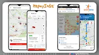
Use ISRO's swadeshi app, made in India, made for Indian - #AatmaNirbharBharat
India will not need to depend upon foreign services for Navigation App. India goes to urge its own navigation app soon. The country will have its own mapping portal and its own geospatial data service. it's providing India with the Indian Space Research Organization (ISRO) together with the indigenous Navigation Service Location and Navigation Technology Solution Provider MapMyIndia.
ISRO partnership with MapMyIndia
Rohan Verma, CEO and Executive Director of MapMyIndia said that satellite image and observation data are going to be made available by ISRO and MapmyIndia will provide the service digitally. He said that after this service, users won’t need to depend upon foreign organizations for navigation services, maps and geospatial services. After this Google Maps won’t feel the necessity of Google Earth.
Department of Space (DOS) has entered into an MoU with M/s CE Info Systems Pvt Ltd today. This will enable DOS and CE Info Systems to jointly identify and build geospatial solutions.
— ISRO (@isro) February 11, 2021
More details: https://t.co/GVJBwgPBy8@MapmyIndia #ISRO pic.twitter.com/NClryE9pHh
Real satellite image on the navigation app
According to ISRO, Department of Space has partnered with MapmyIndia. In this, help of indigenous service like NavIC, Bhuvan are going to be taken. Bhuvan may be a central geo-portal with tools for geospatial data service and analysis.
At an equivalent time, the Indian Regional Navigation Satellite System (IRNSS) is named NavIC (Navigation with Indian Constellation). this is often India’s indigenous navigation system, developed by ISRO. The indigenous navigation app will have a true satellite image. These pictures will meet ISRO. This app are going to be absolutely free and can not accompany any advertising business model.
If you like this blog post, subscribe to my blog, share it with your friends, and don't forget to tag with me on Facebook, Twitter/giteshsharma_, and Instagram. And if you have any doubt, don't hesitate to comments below and contact me on page. You can also do subscribe to me on YouTube/giteshgeeky and Telegram and watch my videos tutorial.

